
Finance Minister Nirmala Sitharaman will present her sixth straight Budget ahead of the Parliamentary elections, matching the record of former Prime Minister Morarji Desai. Sitharaman in her pre-election Budget, which technically is a vote on account and popularly termed an interim Budget, will seek Parliament's nod for a grant in advance to meet the central government's essential expenditure for the first four months of the new fiscal year that starts in April. A new government elected after the April/May general elections will present the full Budget, likely in July.

The Indian Meteorology Department also predicted some respite from the severe heat wave prevailing in several parts of the country.

Large parts of north India reeled under numbing cold on Tuesday with the mercury remaining below freezing point at most places in Jammu and Kashmir, while dense fog in the early hours of the morning hit road and rail traffic movement.

They said the incident occurred around 4 am when a 150-metre-long portion of the four-and-a-half-kilometer-long tunnel collapsed.

Around 29 trains have been delayed by two to five hours due to foggy weather, a railway official said.

Citing the example of last year, he said many pilgrims who came for the yatra from rural areas of Uttar Pradesh had to return from Rishikesh and Haridwar as they had not registered in advance for it.

Images from Day 4 of the fourth Test between India and England in Ranchi on Monday, February 26.

'You don't know what you are going to encounter every 10-20 metres.' 'These mountains are unpredictable.'
Isolated heavy rains have also been forecast over some places during the next 48 hours.

Cyclone 'Biparjoy', the first storm brewing in the Arabian Sea this year, has rapidly intensified into a severe cyclonic storm, with meteorologists predicting a 'mild' monsoon onset over Kerala and 'weak' progress beyond southern peninsular under its influence.

Palghar, Thane, Raigad and Ratnagiri could witness thunderstorm activity, lightning, moderate rain and gusty storm over the next two days.
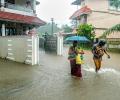
A Red alert, indicating heavy to very heavy rains of over 20 cm in 24 hours, has been sounded for Thiruvananthapuram, Kollam, Pathnamthitta and Alappuzha districts on December 3, while Orange alert (6 cm to 20 cm rains)for Kottayam, Ernakulam and Idukki districts the same day.
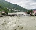
Incessant rains unleashed more death and destruction on Monday in parts of north India, with 37 people killed in landslides and other rain-related incidents in the last two days even as the Army and NDRF teams stepped in to intensify the relief and rescue operations.

The weather department has ruled out any respite from the sweltering heat in the coming days and local government officials have asked people not to venture out in the scorching sun.

While it hit the national capital two days before schedule, its entry into the financial capital is two weeks late, the Met office said.

A tormenting heatwave swept through North India on Sunday with the mercury crossing 49 degrees Celsius in pockets of Delhi, while the weather office forecast some relief Monday onwards.

Addressing a press conference virtually, India Meteorological Department Director General Mrutyunjay Mohapatra said September was likely to witness normal rainfall in the range of 91-109 per cent of the long period average of 167.9 mm.
Taps supplying water to households were frozen due to the cold.

A GLOF occurred in parts of Lhonak Lake, leading to a rapid rise in water levels with very high velocities downstream along the Teesta River Basin in the early hours of October 4. This resulted in severe damage in Mangan, Gangtok, Pakyong and Namchi districts.

Of these four flights (except Qatar Airways) returned to Kozhikode airport as the weather condition in Kozhikode gained normalcy.

The air quality is expected to improve further due to wind speed favourable for the dispersion of pollutants.

Schools and colleges in the city and adjoining districts have been closed as a precautionary measure.

East and northeast India recorded 29 per cent rain deficit -- 141.5 mm against the normal of 199.9 mm -- from March 1 to May 3.

The India Meteorological Department has issued a 'Red Alert' and predicted 'very heavy' to 'extremely heavy' rainfall across several districts of Assam over the next five days.

A punishing cold wave swept Delhi on Monday morning with the minimum temperature at the Safdarjung observatory, the city's base station, plunging to 1.4 degrees Celsius, the lowest in the month since January 1, 2021.

The country also reported 1,750 deaths due to extreme weather events such as floods, cyclonic storms, heavy rain, landslides, lightning, among others, during the year, it said.

The weather department has forecast widespread snowfall or rains over the next two days also.

Delhi's minimum temperature on Wednesday morning plunged to 4.4 degrees Celsius -- the season's lowest -- making the national capital colder than Dharamsala, Nainital and Dehradun.

British supermarkets and pubs are set to enjoy a boost to trade this weekend as families and friends gather for breakfasts and barbecues to watch England's Lionesses play Spain in the Women's World Cup soccer final in Australia.

The south-west monsoon on Tuesday started withdrawing from parts of south-west Rajasthan and adjoining Kutch in Gujarat, with at least eight states, including rice bowl states of Uttar Pradesh and Bihar reporting deficient rains. It was for the first time since 2016 that the monsoon started withdrawing in the third week of September. "Southwest monsoon has withdrawn from parts of southwest Rajasthan & adjoining Kutch today, against its normal date of withdrawal from southwest Rajasthan of September 17," the India Meteorological Department (IMD) tweeted.

Monsoon normally hits Kerala on June 1 but this year, Met department had predicted that it will hit the state on June 5.

Monsoon normally starts withdrawing beginning September 1 from west Rajasthan.

'It is important to understand that the disability is not in the person.' 'The problem lies in societal attitude and the discriminatory treatment given to disabled people in our country.'

The low-pressure area over the South Andaman Sea and adjoining southeast Bay of Bengal is very likely to move northwestwards and intensify into a depression by Saturday, the weather office said.

A severe cold wave brought the minimum temperature down to a numbing 1.5 degrees Celsius at the Ridge weather station in central Delhi.

The IMD has fancy weather-monitoring radars in the name of providing better forecasts.

Operations at the Delhi airport remained normal. However, three flights were returned or diverted to the Delhi airport due to bad weather in Chandigarh, Varanasi and Lucknow on Tuesday night.

Rain or thundershowers have also been predicted in south interior Karnataka and at a few places over Coastal Karnataka and North interior Karnataka.

The southwest monsoon is set to make its exit in style, bringing rains to the parched parts of Uttar Pradesh and Bihar, as weather forecasters have picked up signs of formation of a cyclonic circulation over Bay of Bengal. Addressing a press conference in New Delhi, India Meteorological Department (IMD) director general Mrutyunjay Mohapatra on Thursday junked last week's forecast of early withdrawal of southwest monsoon and announced the extended stay of the seasonal showers. "Even though we expected early withdrawal of the southwest monsoon, a cyclonic circulation over west-central and adjoining northwest Bay of Bengal will shift the monsoon trough southwards around September 7.

At the review meeting, chaired by cabinet secretary Rajiv Gauba in New Delhi, the IMD said above normal maximum temperatures are likely over most parts of northeast, east and central India and some parts of northwest India.
